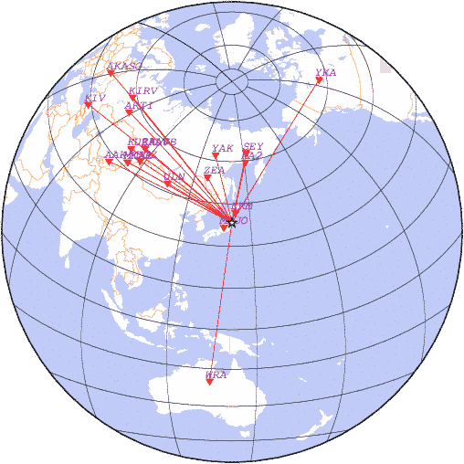
date 2021-03-20 16:41:18, lat 38.26, lon 141.76, depth 60 km, mb: 4.5/8
detemined with station data:
| N | Code | Time | Phase | Delta | Azimuth | Residual | Ms | mb | Network |
|---|---|---|---|---|---|---|---|---|---|
| 1 | MAJO | 16:42:07.6 | P | 3.31 | 240 | 0.3 | - | - | JMA |
| 2 | ERM | 16:42:16.2 | P | 3.90 | 16 | 0.8 | - | - | HSS |
| 3 | ZEA | 16:45:27.4 | P | 18.41 | 332 | -1.0 | - | 4.0 | SAGSR |
| 4 | MA2 | 16:46:08.6 | P | 22.10 | 12 | 0.4 | - | 4.3 | NEGSR |
| 5 | YAK | 16:46:36.1 | P | 24.94 | 346 | 0.5 | - | 4.5 | YAGSR |
| 6 | SEY | 16:46:42.3 | P | 25.54 | 11 | 1.2 | - | 4.2 | NEGSR |
| 7 | ULN | 16:46:54.1 | P | 26.91 | 302 | 0.7 | - | 4.1 | OBM |
| 8 | DGZ | 16:48:47.1 | P | 39.91 | 305 | 1.1 | - | - | ASGSR |
| 9 | ZAA0B | 16:48:56.8 | P | 41.30 | 311 | -0.7 | - | - | RIPT |
| 10 | ZALV | 16:48:57.3 | P | 41.30 | 311 | -0.2 | - | - | RIPT |
| 11 | MK31 | 16:49:17.4 | P | 43.71 | 301 | 0.4 | - | - | NNC |
| 12 | MKAR | 16:49:17.1 | P | 43.92 | 301 | -1.6 | - | - | NNC |
| 13 | KURK | 16:49:30.0 | P | 45.40 | 307 | -0.5 | - | - | NNC |
| 14 | AAK | 16:50:09.6 | P | 50.16 | 298 | 2.3 | - | 4.5 | KYRG |
| 15 | ARTI | 16:50:48.0 | P | 55.73 | 318 | -0.4 | - | 5.0 | OBGSR |
| 16 | WRA | 16:51:06.2 | P | 58.32 | 188 | -0.5 | - | - | CAN |
| 17 | KIRV | 16:51:13.6 | P | 59.44 | 323 | -0.9 | - | - | RIPT |
| 18 | YKA | 16:51:36.1 | P | 62.61 | 31 | 0.1 | - | - | OTTR |
| 19 | KIV | 16:52:23.9 | P | 70.31 | 311 | -1.3 | - | 4.9 | OBGSR |
| 20 | AKASG | 16:52:43.7 | P | 73.50 | 322 | -0.6 | - | - | NSAU |
|
News |
Catalogs |
Wave Forms |
Alert Service |
Software |
Links |
Srtucture |
Publications |
Conferences |
Announce |
About
© FRC GS RAS 1993-2018 |

