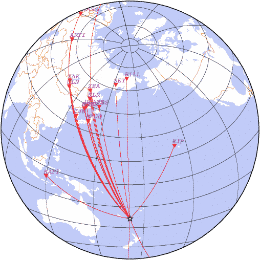
date 2021-02-10 21:49:58, lat -23.44, lon 171.63, depth 10 km, mb: 5.4/13
detemined with station data:
| N | Code | Time | Phase | Delta | Azimuth | Residual | Ms | mb | Network |
|---|---|---|---|---|---|---|---|---|---|
| 1 | KAPI | 21:59:18.7 | P | 53.19 | 282 | 1.7 | - | 5.4 | DJA |
| 2 | KIP | 21:59:20.8 | P | 53.50 | 36 | 1.5 | - | 5.7 | HON |
| 3 | MAJO | 22:00:54.3 | P | 67.49 | 331 | -0.7 | - | 5.4 | JMA |
| 4 | TJN | 22:01:26.1 | P | 72.71 | 324 | -1.0 | - | - | TJN |
| 5 | YSS | 22:01:40.0 | P | 74.77 | 340 | 0.9 | - | 5.1 | SAGSR |
| 6 | MSHR | 22:01:43.1 | P | 75.56 | 330 | -0.6 | - | 5.4 | OBGSR |
| 7 | PSTR | 22:01:44.9 | P | 75.77 | 330 | -0.0 | - | 5.9 | OBGSR |
| 8 | USA0B | 22:01:49.0 | P | 76.47 | 332 | 0.1 | - | - | RIPT |
| 9 | KLR | 22:02:11.9 | P | 80.61 | 335 | 0.2 | - | 5.5 | OBGSR |
| 10 | SNAA | 22:02:35.0 | P | 85.07 | 182 | 0.2 | - | 5.5 | AWIB |
| 11 | ZEA | 22:02:38.8 | P | 85.88 | 335 | -0.1 | - | 5.0 | SAGSR |
| 12 | SEY | 22:02:46.6 | P | 87.42 | 351 | 0.2 | - | 5.2 | NEGSR |
| 13 | BILL | 22:03:03.7 | P | 91.31 | 358 | -0.9 | - | 5.1 | NEGSR |
| 14 | ULN | 22:03:06.5 | P | 91.54 | 323 | 0.8 | - | 5.3 | OBM |
| 15 | ZAK | 22:03:21.8 | P | 94.98 | 323 | 0.3 | - | 5.1 | BAGSR |
| 16 | HOPE | 22:03:37.9 | P | 98.89 | 164 | -1.1 | - | - | BASV |
| 17 | ARTI | 22:08:53.1 | PKIKP | 122.03 | 323 | -0.5 | - | - | OBGSR |
| 18 | AKASG | 22:09:28.9 | PKIKP | 140.18 | 323 | -1.3 | - | - | NSAU |
| 19 | BFO | 22:09:54.7 | PKIKP | 151.84 | 336 | 0.4 | - | - | KRW |
|
News |
Catalogs |
Wave Forms |
Alert Service |
Software |
Links |
Srtucture |
Publications |
Conferences |
Announce |
About
© FRC GS RAS 1993-2018 |

