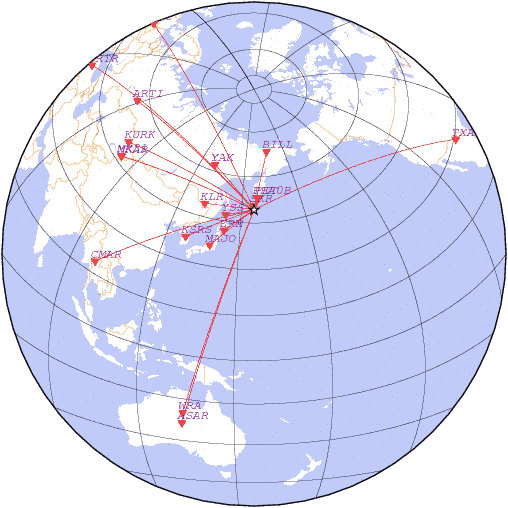
date 2018-10-10 17:02:17, lat 49.25, lon 156.10, depth 33 km, mb: 4.2/9
detemined with station data:
| N | Code | Time | Phase | Delta | Azimuth | Residual | Ms | mb | Network |
|---|---|---|---|---|---|---|---|---|---|
| 1 | SKR | 17:02:43.8 | P | 1.43 | 0 | 2.2 | - | - | SAGSR |
| 2 | PEA0B | 17:03:18.9 | P | 3.99 | 14 | 0.8 | - | - | RIPT |
| 3 | PET | 17:03:18.9 | P | 4.10 | 22 | -0.7 | - | - | KAGSR |
| 4 | YSS | 17:04:30.1 | P | 9.21 | 261 | -1.1 | - | - | SAGSR |
| 5 | ERM | 17:05:02.6 | P | 11.59 | 236 | -1.1 | - | - | HSS |
| 6 | KLR | 17:05:59.7 | P | 15.90 | 279 | -0.7 | - | - | OBGSR |
| 7 | MAJO | 17:06:30.7 | P | 18.20 | 232 | 1.4 | - | 4.3 | JMA |
| 8 | YAK | 17:06:42.0 | P | 19.44 | 321 | -1.9 | - | 4.4 | YAGSR |
| 9 | BILL | 17:06:43.8 | P | 19.57 | 12 | -1.4 | - | 4.2 | NEGSR |
| 10 | KSRS | 17:07:28.5 | P | 23.53 | 251 | 2.9 | - | 3.5 | USAF |
| 11 | MK31 | 17:10:52.1 | P | 47.59 | 297 | 0.2 | - | - | NNC |
| 12 | KURK | 17:10:52.2 | P | 47.67 | 303 | -0.2 | - | 4.8 | NNC |
| 13 | MKAR | 17:10:51.8 | P | 47.77 | 297 | -1.5 | - | - | NNC |
| 14 | ARTI | 17:11:44.3 | P | 54.63 | 317 | -0.6 | - | 4.9 | OBGSR |
| 15 | CMAR | 17:11:48.9 | P | 54.90 | 257 | 1.5 | - | - | BKK |
| 16 | WRA | 17:13:35.9 | P | 71.56 | 202 | -1.4 | - | - | CAN |
| 17 | TXAR | 17:13:54.0 | P | 74.54 | 63 | -0.8 | - | 3.7 | USAF |
| 18 | ASAR | 17:13:58.6 | P | 75.24 | 201 | -0.3 | - | - | AUST |
| 19 | KHC | 17:14:09.1 | P | 76.82 | 336 | 1.7 | - | 4.4 | GFU |
| 20 | BRTR | 17:14:14.7 | P | 77.90 | 318 | 1.1 | - | 3.6 | ISK |
|
News |
Catalogs |
Wave Forms |
Alert Service |
Software |
Links |
Srtucture |
Publications |
Conferences |
Announce |
About
© FRC GS RAS 1993-2018 |

