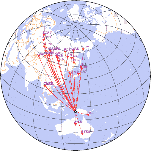
date 2026-02-14 09:48:15, lat -5.10, lon 134.32, depth 10 km, mb: 4.8/22
detemined with station data:
| N | Code | Time | Phase | Delta | Azimuth | Residual | Ms | mb | Network |
|---|---|---|---|---|---|---|---|---|---|
| 1 | PMG | 09:51:28.4 | P | 13.43 | 109 | 2.3 | - | - | PMG |
| 2 | WRAB | 09:51:42.7 | P | 14.74 | 180 | -1.3 | - | - | CAN |
| 3 | WRA | 09:51:42.4 | P | 14.76 | 180 | -1.8 | - | - | CAN |
| 4 | STKA | 09:54:04.3 | P | 27.49 | 167 | 2.4 | - | 4.8 | AUST |
| 5 | MAJO | 09:56:02.5 | P | 41.58 | 5 | -0.8 | - | 4.6 | JMA |
| 6 | TJN | 09:56:06.0 | P | 41.77 | 352 | 1.2 | - | 4.7 | TJN |
| 7 | CMAR | 09:56:08.3 | P | 42.01 | 305 | 1.6 | - | - | BKK |
| 8 | CM31 | 09:56:06.4 | P | 42.01 | 305 | -0.3 | - | 4.3 | BKK |
| 9 | CHTO | 09:56:09.1 | P | 42.19 | 305 | 0.9 | - | - | BKK |
| 10 | ERM | 09:56:50.6 | P | 47.58 | 9 | -0.5 | - | 5.6 | HSS |
| 11 | JKA | 09:57:06.2 | P | 49.55 | 8 | -0.2 | - | 5.3 | IDC |
| 12 | KLR | 09:57:40.6 | P | 54.16 | 358 | -0.1 | - | 4.5 | OBGSR |
| 13 | ULN | 09:58:09.1 | P | 57.93 | 339 | 1.3 | - | 4.6 | OBM |
| 14 | ZEA | 09:58:15.4 | P | 58.94 | 355 | 0.6 | - | 4.4 | SAGSR |
| 15 | TUP | 09:58:26.3 | P | 60.52 | 350 | 0.6 | - | 4.6 | BAGSR |
| 16 | ZAK | 09:58:33.1 | P | 61.41 | 338 | 1.4 | - | 4.5 | BAGSR |
| 17 | MOY | 09:58:44.9 | P | 63.31 | 337 | 0.4 | - | - | BAGSR |
| 18 | ORL | 09:58:51.9 | P | 64.44 | 337 | -0.1 | - | 4.7 | BAGSR |
| 19 | PDYAR | 09:59:06.0 | P | 66.84 | 348 | -1.5 | - | - | RIPT |
| 20 | YAK | 09:59:08.7 | P | 67.03 | 358 | 0.0 | - | 5.6 | YAGSR |
| 21 | DGZ | 09:59:15.5 | P | 67.99 | 329 | 0.8 | - | 4.8 | ASGSR |
| 22 | MK31 | 09:59:22.5 | P | 69.09 | 325 | 0.8 | - | 4.9 | NNC |
| 23 | SEY | 09:59:21.1 | P | 69.23 | 9 | -1.4 | - | 4.8 | NEGSR |
| 24 | MKAR | 09:59:22.6 | P | 69.28 | 324 | -0.2 | - | - | NNC |
| 25 | ZAA0B | 09:59:36.2 | P | 71.87 | 332 | -2.5 | - | 4.6 | RIPT |
| 26 | ZALV | 09:59:38.4 | P | 71.87 | 332 | -0.3 | - | - | RIPT |
| 27 | AAK | 09:59:40.3 | P | 71.95 | 318 | 1.1 | - | 4.5 | KYRG |
| 28 | KURK | 09:59:46.5 | P | 73.22 | 327 | -0.2 | - | 4.8 | NNC |
| 29 | BORK | 10:00:19.1 | P | 78.86 | 326 | 0.3 | - | 4.8 | NNC |
| 30 | ARTI | 10:00:56.9 | P | 86.49 | 327 | -1.5 | - | 4.6 | OBGSR |
| 31 | KIRV | 10:01:20.1 | P | 91.66 | 329 | -2.7 | - | 5.0 | RIPT |
|
News |
Catalogs |
Wave Forms |
Alert Service |
Software |
Links |
Srtucture |
Publications |
Conferences |
Announce |
About
© FRC GS RAS 1993-2018 |

